RAMS BACKGROUND
Introduction
South Africa is highly reliant on a sufficient and effective road network, which serves as a backbone for the movement of people, goods and services. The roads infrastructure links economic hubs to each other and is vital to the economy of the country. In order to ensure that the road network is maintained at an optimal level, the South African Government, through the National Treasury, has allocated funding for the establishment of a Rural Roads Asset Management (RRAMS). The objective of this allocation is to ensure effective investment in rural and municipal roads, through the development of a Rural Roads Asset Management. This allocation is to assist district municipalities to:
- implement an RRAMS
- establish a road network inventory
- collect road condition data
- collect traffic data
- collect data on rural access bridges and culverts
According to the RRAMS grant, the system shall be utilised, in compliance with COTO, TRH and TMH standards, to identify and prioritise the maintenance requirements within the relevant budget limit, to improve condition of the roads and extend the lifespan of road infrastructure.
RRAMS Grant Requirements
The detailed requirements and conditions of the RRAMS grant, as published in the Division of Revenue Bill (DORA), is summarised below:
| Rural Roads Asset Management Systems Grant | |
| Strategic goal |
|
| Grant purpose |
|
| Outcome statements |
|
| Outputs |
|
Priority outcome(s) of government that this grant primarily contributes to |
|
Details contained in the business plan |
|
| Conditions |
|
Responsibilities of the transferring national officer and receiving officer |
|
|
|
Process for approval of business plans |
|
The objectives of the RRAMS grant can be summarised as follow:
- improved data on rural roads to guide infrastructure investments
- efficient use can be made of available budgets in order to reduce vehicle operating costs and extend the remaining life of rural roads by means of scientific network management techniques
- creation of employment an enhancing the human capacity at municipalities for the operation of RAMS within local municipalities
RAMS Maturity Levels
RAMS operate at different maturity levels, ranging from simple systems to extremely complex integrated systems, as depicted in the diagram below. As complexity increases so does the cost, expertise and manpower to operate and maintain the system. According to TMH22, the minimum COLTO requirement is that all Provincial Authorities operate Level II RAMS and Municipal Authorities a Level I RAMS. The GeoRAMS platform is a Level 1 RAMS.
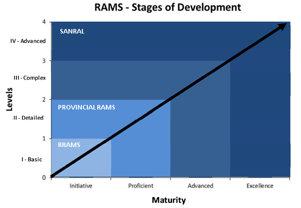
Stages of RAMS Maturity (source: TMH22)
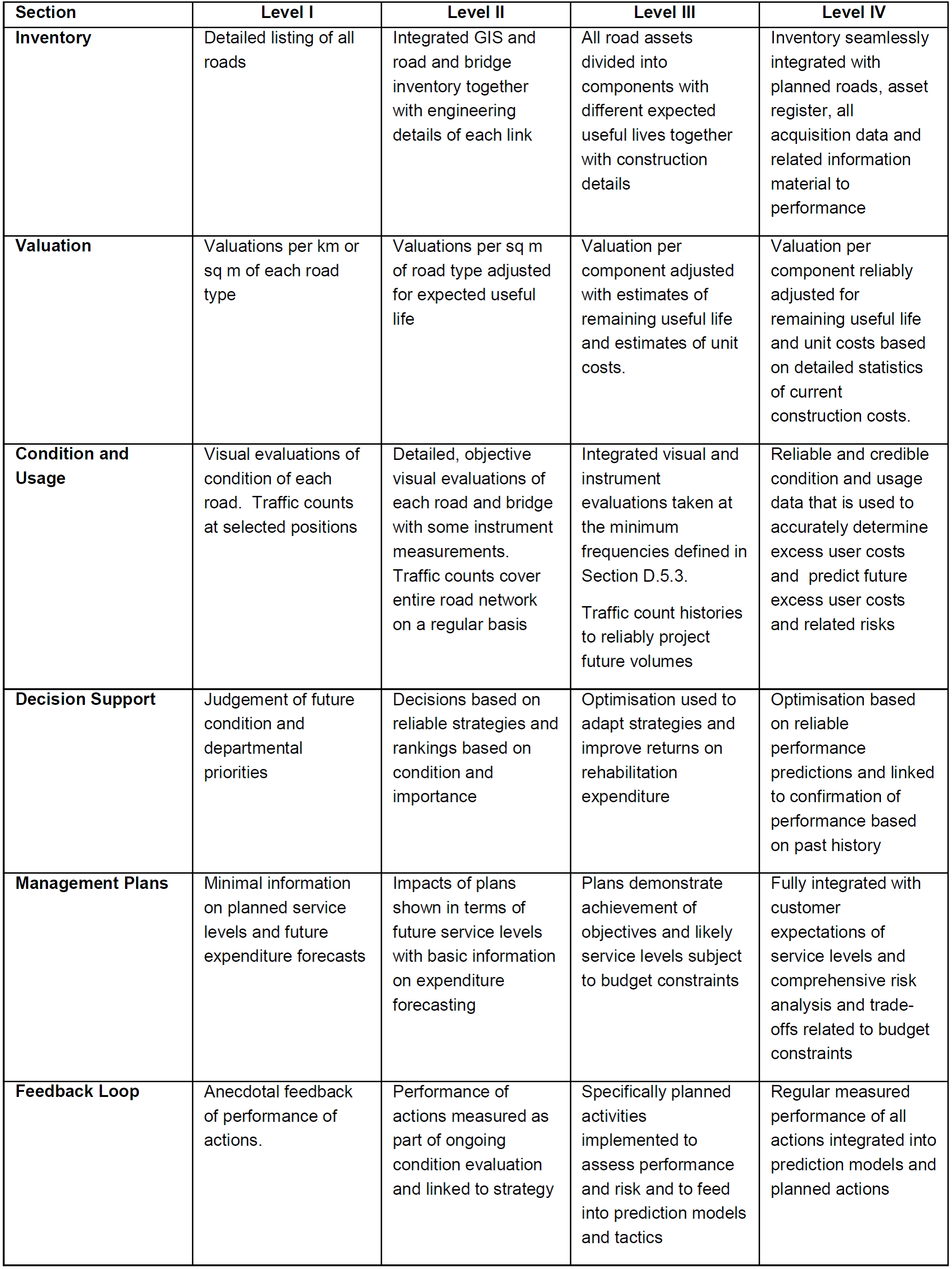
The table below describes the differences between the maturity levels, from basic (level 1) to advanced (level 4).
RRAMS Data Collection Process
The roads infrastructure is dynamic and is continuously changing; new roads are being built, roads are rehabilitated, roads deteriorate over time etc. In order to ensure that the information in RRAMS remains valid and current, data about roads infrastructure must be collected on an ongoing basis. The RRAMS grant conditions stipulate that:
- for RISFSA Class R1, R2 and R3 roads, visual condition data must not be older than two years
- for RISFSA Class R4 and R5 roads, visual condition data must not be older than three years
Given the dynamic status of the roads infrastructure and the cyclic nature of the data collection process, it is important to understand that the accuracy of the data in RRAMS improves over time (on condition that regular data collection exercises are conducted).
The type and methods used to collect data for RRAMS are briefly described below:
Road Network Inventory (RNI)
A road network inventory (RNI) is established by collecting the following information about roads:
- road geometry (spatial definition)
- road name
- road length
- the surface type (paved/gravel/block/concrete)
- administrative regions (such as town, district and local municipality)
- the road classification (RISFSA)
This information can either be sourced from third parties, collected in the field using GPS devices or digitised using Google Maps or ortho-imagery, for example.
Roads are segmented into discrete sections, referred to as road links and defined as follows:
- an intersection another road
- a change of surface from paved to gravel (or vice versa)
- the start or end of a roadway
- the start or end of a dual carriageway
- the start or end of a subsidy
Each road link is assigned attribution with information pertaining to the road link and its ordinal position within the road chainage. This includes:
- an incremental link identifier number
- the from_km and to_km
- the length of the road_link in km
- the from and to descriptions
- the from and to node types
Road Classification
| Road Class | Description |
|---|---|
| 1 | Primary Distributors, providing high mobility with limited access for rapid movement of large volumes of people, raw materials, manufactured goods and agricultural produce of national importance. |
| 2 | Regional Distributors providing relatively high mobility with lower levels of access for the movement of large volumes of people, raw materials, manufactured goods and agricultural produce of regional importance in rural and urban areas. |
| 3 | District Distributors, providing moderate mobility with controlled higher levels of access for the movement of people, raw materials, manufactured goods, agricultural produce in rural and urban areas of regional importance. |
| 4 | District Collectors, providing high levels of access and lower levels of mobility for lower traffic volumes of people, raw materials, manufactured goods and agricultural produce in rural and urban areas of local importance. |
| 5 | Access Roads, providing high access and very low mobility routes for the movement of people and goods within urban and rural areas. |
All roads are allocated classes according to the Road Infrastructure Strategic Framework for South Africa (RISFSA) , as per the table below:
Road classification is an indication of the economic importance of a road, the lower the class the higher the importance.
Road Condition Data
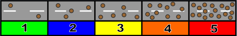
Road condition assessments are carried out by means of visual condition surveys in accordance with TMH9 (flexible roads) and TMH12 guidelines (gravel roads). Assessors assign degree and extent ratings to surfacing and structural defects (such as surface cracking and potholes) as well as functional characteristics such as riding quality and skid resistance.
The rating scores are done on a scale of 1 to 5 (4 with functional
distresses) where  1: slight,
  2: isolated,
  3:
moderate,
3:
moderate,  4: warning and
  5: severe problems.
Degree

Extent
Traffic Data
Traffic volume is one of the most important parameters in RAMS related models such as performance modelling and road deterioration, treatment selection, prioritisation and optimisation. Traffic data reflect both economic activity and factors that directly affect and accelerate pavement deterioration.
The data are normally reported by calculating the following:
- average daily traffic (ADT)
- annual average daily traffic (AADT)
- vehicle kilometres (AADT x length of the road)
- percentage heavy vehicles (as these are the vehicles that have the most adverse effect on road deterioration)
AADT is by far the most important representation of traffic on a road network and is used as a base input to many RAMS calculations and models. Calculating AADT is, however, complex as account needs to be made for seasonal, weekly and day/night distributions as well as traffic volume drift over time in relation to economic stimuli.
Gathering data on traffic is costly and needs to occur frequently in specified cycles. Due to budget constraints, it is not possible to collect 24/7/365 traffic data on all roads. For this reason, a sampling approach is typically adopted. Good results can be obtained by manually counting traffic (via 12hr (06:00 to 18:00) counts) on a third of the network nodes each year and supplementing these data with 7-day automatic temporary counts in order to calculate day/night distributions (for the calculation of ADT) and weekly distributions (for the calculation of AADT). The calculation of AADT can be greatly improved by including seasonal distribution and growth rate factors calculated from permanent count stations.
Counts are typically classified such that traffic is counted according to the five vehicle classes as indicated in the table below. To avoid pseudo growth trends, counts are typically not conducted during holiday periods (such as school and public holidays) or weekends.
| Classification | Description | |
|---|---|---|
|
Light | Light vehicles are motor vehicles with a gross vehicle mass of less than 3 tonnes. It includes motorcycles and motor cars with or without trailers and caravans. |
|
Heavy | The heavy vehicle class includes single-chassis or articulated heavy vehicle (truck or bus) with a gross vehicle mass of between 3 tonnes and 16 tonnes. The heavy vehicles in this class have up to 3 axles, at least one of which has more than one wheel on each side. |
|
Very Heavy | Very heavy vehicles are articulated heavy vehicles with a gross vehicle mass of greater than 16 tonnes. The heavy vehicles in this class have more than 3 axles, at least one of which has more than one wheel on each side. |
|
Bus | Buses are heavy vehicles adapted for the conveyance of groups of people with a seating capacity of 40 or more. |
|
Taxi | Taxis are light vehicles adapted for the conveyance of groups of people with a seating capacity of up to 40. |


| Class | Functional Classification | Description | Speed (km/h) |
|---|---|---|---|
| 1 | Freeway / Expressway | Freeway with no at grade intersections, regional traffic, high design speed and exclusive mobility function | 120 |
| 2 | Major Arterial Street Regional Distributor Road | Typically provide a link between cities / towns or a major distributor within a city, high mobility function | 80 - 100 |
| 3 | Arterial Street | Link between major suburbs and the CBD or between 2 suburbs, mobility function | 60 - 80 |
| 4 | Collector Street | Important link between class 5 and 3 roads, access function with limited mobility | 60 |
| 5 | Access Street | Provide access to private erven | 50 -60 |
Road-side Furniture
The collection of data regarding road-side furniture is considered a lower priority for RRAMS and is typically only gathered after RNI, road condition and traffic data has been collected. Road-side furniture to be captured (as per THM22 ) include:
- Guardrails
- Road signs
- Road markings
- Bus shelters
- Minor retaining structures
Bridge data collection
Data on the condition of bridges must also be captured as part of RRAMS, however RRAMS is not a bridge management system. Condition assessment of bridge structures can only be carried out by qualified and registered bridge inspectors.
RRAMS Output
According to the RRAMS grant, the system must be utilised, to identify and prioritise the maintenance requirements within the relevant budget limit, to improve condition of the roads and extend the lifespan of road infrastructure.
Calculations
In order to determine treatment actions, the system must perform calculations from the visual condition and traffic data. Several indices are calculated from the data.
These indices, comprising engineering condition indices (ECIs) and functional indices (FIs), allow various problems on the road network to be highlighted to assist in identifying possible remedial measures and the prioritisation thereof. The EIs are based on the condition of individual components of the asset, rated from an engineering point of view with the view of maintaining the asset in an acceptable condition. The FIs are based on an appraisal of the asset in terms of functional characteristics that affect the quality of use, notably comfort (convenience) safety, congestion and operating cost (TMH22). The table below lists the items that are calculated by the system:
| Calculation/Index | Description |
|---|---|
| VCI | Visual Condition Index (Aggregation method per TRH22) |
| RCI | Reseal Condition Index (Aggregation method per TRH22) |
| CISURF | Surfacing Condition Index (Deduct method per TMH22) |
| CIFPAVE | Condition Index – Flexible Pavement Structure (Deduct method per TMH22) |
| CICPAVE | Condition Index – Concrete Pavement Structure (Deduct method per TMH22) |
| CIBPAVE | Condition Index – Block Pavement Structure (Deduct method per TMH22) |
| CIUNPAVED | Condition Index – Unpaved Roads (Deduct method per TMH22) |
| CIBRIDGE | Bridge Condition Index (Struman DERU algorithm) |
| PIROAD | Priority Index for Road (TRH22) – uses weighting factor of the selected remedial action for each road section together with the road class |
| PIBRIDGE | Priority Index for Bridge (Struman PI algorithm) |
| EVU | Equivalent Vehicle Units |
| Vkm | Vehicle Kilometres |
| AADT | Annual Average Daily Traffic |
| %HV | Percentage Heavy Vehicles |
| Road Capacity | Equivalent Vehicle Units (EVUs) per day |
| CRC | Current Replacement Cost |
| CDRC | Current Depreciated Replacement Cost |
| NCN | Network Condition Number |
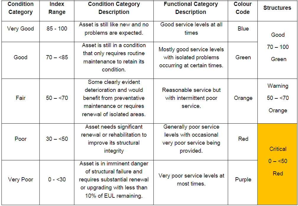
All condition-based indices are presented in summarised form, expressed per LM, town, RISFSA class, and surface type and is presented according to the categories listed in the table below:
RRAMS Report and Data
According to the conditions of the RRAMS grant, a road condition report must be submitted to the National Department of Transport (NDoT) on an annual basis, contain the following:
- the extent of the road network in the municipality
- the condition of the network in the municipality
- the status of the municipality’s RAMS
- the proportion of municipal roads with updated data captured on its RAMS
The municipality is also responsible for submitting RRAMS data to NDoT on an annual basis.
Capacity Building
One of the objectives of the RRAMS grant is to build human capacity for the operations of the system within municipalities. The grant provides opportunities for unemployed civil technicians to be employed and capacitated under the project. With the required training and support, graduates become responsible for collecting information, such as condition and traffic data, as required by the system.